
Old Maps and Globes > Holy Land Maps
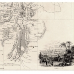
Map of Palestine 1850. Made by Petermann and Dower, Published by Orr, London.
Item#: MAH1089
SOLD

Palestine Ancient and Modern. Map By Petermann and Dower 1850. Constructed by the famous Augustus Petermann FRGS Engraved by: I. Dower of Pentonville London, and published by Orr & Co. Amen Corner, Paternoster Row. Published circa 1850. Size (width X height): 9 X 11 inches. Color and Method: Original hand color copper-engraved map. Map Description: This map shows the territories of the 12 tribes of Israel that were aligned on both banks of the river Jordan, and emphasizes the Jewish Biblical Borders before the exile. Some geographic features are inaccurate especially costal features. An interesting added feature to this map, are two cross section one from the Mediterranean coast near Acre through the see of Galilee to the Golan (CD) and a second from Jaffa to the north part of the Dead Sea (AB) The sections shows heights of different mountains in reference to the Sea of Galilee and the Dead Sea.
Related Items
-
 Price: $65.00
 -
 Price: $55.00
 -
 Price: $150.00
Development: Epoch | Design: Luch
Copyright © 1999-2025 Gilai Collectibles. All Rights Reserved