
Old Maps and Globes > Holy Land Maps
Map of Canaan 1880. Drawn and Engraved by Hughes, Published by Murdoch, London.
Item#: MAH1079
SOLD

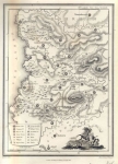
Map of Canaan As Divided Between the Jewish Tribes. Drawn and engraved by: W. Hughes. Published by J.G. Murdoch London. Year printed: 1880. Size (width X Height): 7 X 10 inches. Printed in colors. Map Description: This very interesting map showing the ancient boundaries of the 12 Jewish tribes. These regions are printed in different colors on the east and west side of the River Jordan. Biblical Jewish settlements and Roman towns and villages are marked and a list of their modern names is printed. The Biblical territories, Bashan, Gilad and Moab are marked on the east of the River Jordan, and Sidonians, Plain of Sharon and Philistines are along the Great Sea Coast. The height of several important places is given in feet.
Related Items
-
 Price: $55.00
 -
 Price: $60.00
 -
 Price: $350.00
Development: Epoch | Design: Luch
Copyright © 1999-2026 Gilai Collectibles. All Rights Reserved