
Old Maps and Globes > Holy Land Maps
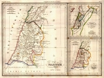
Modern Palestine Published by Tallis


Modern Palestine from the ‘Illustrated Atlas, And Modern History Of The World’ Volume: The British Colonies; Their History, Extent, Condition and Resources. By R. Montgomery Martin, Esq., former Treasurer to the Queen at Hong Kong. Drawn & Engraved by J. Rapkin. Published by J & F Tallis London & New York. Year Printed: 1851 Size: 10 X 14 inches. Color and Method: Original water-colored steel plate engraving with 4 vignettes by H. Warren, Engraved by R. Baker: Gazelle, Natives of Mount Lebanon, Nazareth, and Jaffa. The original illustrations were not painted. Later in the Nineteenth Century, many owners of Tallis atlases commissioned colorists to tint the beautiful vignettes.
Map description: The map shows the boundaries of the Land of Israel at the time of the Ottoman rule. There is color outline by region: El Kuds, Yafa, Nablus, Haifa etc. The map depicts cities, towns, villages as well as mountains, valleys and major roads.
No foxing or tearing. John Tallis was born in 1815/6. He opened his company which published views, maps and atlases in London from roughly 1838. In 1842 his brother Frederick joined the company. The company was dissolved in 1851.
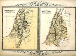
Related Items
-
 Price: $75.00
 -
 Price: $60.00
 -
 Price: $30.00
Development: Epoch | Design: Luch
Copyright © 1999-2024 Gilai Collectibles. All Rights Reserved