
Old Maps and Globes > Jerusalem Maps
Sir W. FitzGerald report and a map illustrating the Jewish proposals for Jerusalem in 1945.
Item#: MAJ1446
SOLD


This item includes a booklet and a map. The booklet is the original report written by Sir William FitzGerald on the "Local Administration of Jerusalem", submitted to the High Commissioner of Palestine on 28th August 1945. This is copy number 14 of 1946 copies printed by the Government Printer Office in Palestine. The report summarizes the history of Jews, Christians and Arabs in Jerusalem and suggests a detailed proposal for dividing or partitioning Jerusalem between Jews and Arabs. The report proposes to create a Western and Eastern Boroughs, each having a mayor and council.
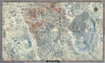
The map is a rare and important map illustrating the Jewish proposals for Jerusalem. Drawn and Published by the Survey of Palestine, Jaffa. Year Published: 1936, Revised in 1946. Printed by the Government Printer, Palestine. Size (width X Height): 36 cm X 37 cm. During 1940’s the population figures of Jerusalem were 92,000 Jews, 32,000 Arabs and 27,000 Christians. The Arabs disagree with the majority voters electing a Jew as the Mayor of the municipal government. The High Commissioner of Palestine appointed Sir William FitzGerald to inquire into the problem and suggest a solution.
To read the report, click here:
http://www.gilai.com/article_61/Sir-William-Fitzgerald-Report-on-Jerusalem-1945
Related Items
-
 Price: $250.00
 -
 Price: $50.00
 -
 Price: Contact us
Development: Epoch | Design: Luch
Copyright © 1999-2026 Gilai Collectibles. All Rights Reserved