
Old Maps and Globes > Jerusalem Maps
Jerusalem in 3 Dimentions 1969


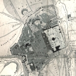
This is a bird’s eye view map of Jerusalem as it was between 1967 and 1969. Hermann Bollmann was a German cartographer who was commissioned by Wim van Leer to make a 3 dimensional map of Jerusalem. The draftsmanship of this map is extremely precise and is based on 187,000 ground and aerial photographs. The map depicts every building, with every window and balcony. Prominent are, of course, the Old City with its walls and the Dome of the Rock, the red roofed buildings of the older neighborhoods, the stadium at the Hebrew University campus, and the newly erected Knesset (Parliament) building. Around the map is an illuminated border featuring the name Jerusalem in 16 languages.
The map is in very good condition. Its overall size is 55 x 91 cm. Publication: Wim van Leer Publications, 1969
The map is in very good condition. Its overall size is 55 x 91 cm. Publication: Wim van Leer Publications, 1969
Related Items
-
 Price: Contact us
 -
 Price: $65.00
 -
 Price: $50.00
Development: Epoch | Design: Luch
Copyright © 1999-2024 Gilai Collectibles. All Rights Reserved