
Old Maps and Globes > Holy Land Maps
Palestine by Malte-Brun, Paris, circa 1835


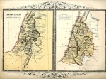
This map is from the atlas "Precis de la geographie Universelle" by Malte-Brun, published in the first quarter of the 19th century. The map depicts 3 maps of different eras in the Biblical period. A)Palestine -the land during the Roman rule. B) Royaume des Israelites sous David et Salomon - The kingdom of David and Salomon. 3) Les Douze Tribus - the twelve Tribes. Conrad Malte-Brun, (1775-1826) was a Danish geographer who was a founder and the first secretary of the Société de Géographie de Paris (1821), the map was engraved by Thierry of rue des Mathurins St.Jacques No.1, Paris. The map is in very good condition with minute foxing and no rips tears or cracks. The map measures approx 15" x 11", (38 cm x 28 cm).
Related Items
-
 Price: $44.00
 -
 Price: $60.00
 -
 Price: $55.00
Development: Epoch | Design: Luch
Copyright © 1999-2025 Gilai Collectibles. All Rights Reserved