
Old Maps and Globes > Holy Land Maps
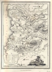
Map of Palestine or the Holy Land 1872. Drawn and Engraved by Gamble. Published by Mitchell.
Item#: MAH1076
SOLD

A New Map of Palestine or the Holy Land. Drawn and engraved by W.H. Gamble. Published by: Samuel Augustus Mitchell, Philadelphia. Year printed: 1872. Size (width X height): 12 X 14 ½ inches. Color and Method: hand-colored with watercolor and stone engraved. Map Description: An attractive hand painted map of Palestine (present day Israel). The map shows The ancient Jewish boundaries and territories of the 12 Jewish tribes. These regions are individually hand-colored on the east and west side of the River Jordan. The ancient Roman divisions: Judea, Samaria, Galilee, Phoenicia (Present Day Lebanon), Perea (Present Day Jordan) and Decapolis (Present Day Syria), are emphasized. Scale: 15 miles to an inch. Inset Description: ‘Modern Jerusalem’. Based on the map of the Palestine Exploration Fund, 1869.
Related Items
-
 Price: $55.00
 -
 Price: $60.00
 -
 Price: $30.00
Development: Epoch | Design: Luch
Copyright © 1999-2026 Gilai Collectibles. All Rights Reserved