
Old Maps and Globes > Jerusalem Maps
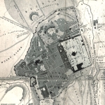
A Proposal Map For Dividing Jerusalem Between Jews and Arabs 1936. Drawn and Published by the Survey of Palestine, Jaffa.
Item#: MAJ1096
SOLD

A Proposal for dividing Jerusalem between Jews and Arabs. Drawn and Published by the Survey of Palestine, Jaffa. Year Published: 1936, Revised in 1946. Printed by the Government Printer, Palestine. Printed in 4 colors. Size (width X Height): 16 inch X 19 inch. Map Description: This is a rare and important map proposes a division of Jerusalem between Jews and Arabs. During 1940’s the population figures were 92,000 Jews, 32,000 Arabs and 27,000 Christians. The Arabs disagree with the majority voters electing a Jew as the Mayor of the municipal government. The High Commissioner of Palestine appointed Sir William FitzGerald to inquire into the problem and suggest a solution. The map is part of his report that suggests creating a Western and Eastern Boroughs, each having a mayor and council. Map Source and Reference: Report by Sir William Fitzgerald on the Local Administration of Jerusalem. Presented to the High Commissioner of Palestine, 28th August 1945. The complete report is included with the map.
Related Items
-
 Price: Contact us
 -
 Price: $350.00
 -
 Price: $50.00
Development: Epoch | Design: Luch
Copyright © 1999-2024 Gilai Collectibles. All Rights Reserved