
Old Maps and Globes > Holy Land Maps
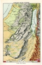
Map of Ancient Palestine 1851. Drawn and Engraved by Rupkin, Published by Tallis & Co. London.
Item#: MAH1077
SOLD


Ancient Palestine. Drawn & Engraved by J. Rupkin. Published by John Tallis & Co. London & New York. Year Printed: 1851. Size (width X Height): 10 X 14 inches. Color and Method: Original water-colored steel plate engraving with 5 color illustrations by H. Warren, Engraved by J. B. Allen. Map Description: This important and decorated map shows the ancient boundaries and territories of the 12 Jewish tribes. These regions are individually hand-colored on the east and west side of the River Jordan. The ancient Roman divisions: Judea, Samaria, Galilee, Phoenicia (Present Day Lebanon), Perea (Present Day Jordan) and Decapolis (Present Day Syria), are emphasized. Biblical Jewish settlements and Roman towns and villages are marked. Scale: about 17 miles to an inch.
Related Items
-
 Price: $44.00
 -
 Price: $30.00
 -
 Price: $60.00
Development: Epoch | Design: Luch
Copyright © 1999-2026 Gilai Collectibles. All Rights Reserved