
Old Maps and Globes > Holy Land Maps
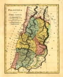
Map of Palestine 1873 Published by Marcus Ward & Co. Belfast.
Item#: MAH1086
SOLD

Color Map Of Palestine by Marcus Ward & Co 1873. This is a map of the Holy Land depicting the Roman division into 4 main regions Judea, Samaria, Galilea and Perea. The map was printed by the publishing company Marcus Ward & Co. (Belfast & London) which was known for it's excellence in printing high quality decorative Christmas Cards during the Victorian period. In 1867 the company opened an office and showroom in London. It went into dissolution in 1899. The map measures 27.5 X 37 cm (11 X 14 ½ inches). At the bottom left of the map are the lists of the six cities of refuge and the five towns of the Philistines. At bottom right is an inset map of Jerusalem in the time of Jesus, showing the Temple, Calvary, Gethsemane and more. The map is in very good condition except for some slight fold creases.
Related Items
-
 Price: $55.00
 -
 Price: $200.00
 -
 Price: $44.00
Development: Epoch | Design: Luch
Copyright © 1999-2024 Gilai Collectibles. All Rights Reserved