
Old Maps and Globes > Jerusalem Maps
Complete and Rare set of 6 Topographic Maps of Jerusalem. Published by the Survey of Palestine 1945.
Item#: MAJ378
SOLD

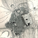
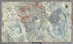
A unique set of 6 folded topographic maps scaled 1:10,000 of Jerusalem. Compiled and printed by the Survey of Palestine in 1945/46 and reprinted in Israel in 1949. The large scale (1:10,000), allowing for close details down to building level. Aside from the roads the maps show sites of public interest such as schools, churches, synagogues, mosques, recreational areas (tennis courts, cinemas, etc.) and important buildings. The maps are in an exceptional state. No foxing, only very little yellowing and no tears.
Related Items
-
 Price: Contact us
 -
 Price: $76.00
 -
 Price: $250.00
Development: Epoch | Design: Luch
Copyright © 1999-2024 Gilai Collectibles. All Rights Reserved