
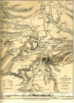
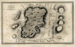
Old Maps and Globes > Jerusalem Maps
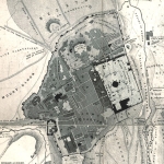
The Most Accurate Map of The Old City of’Jerusalem, Published by: W. de Gruyter & Massada. 1973


‘Jerusalem – The old city’. Cartographic production: Walters-Noordhoff, Groningen. Published by: W. de Gruyter & Massada. Year Published: 1973. Production Place: Israel. Size (width X height): 12 X 17 inch. Color and Method: Original Color Print. Scale 1:4000. Map Description: Detailed and very accurate English and Hebrew description of land use in the old city as was in 1967. Index and Explanations: Color index of land used for residence, trade and personal services, institutions, public administration offices, green areas, ruins etc. Condition of map: Mint. Map Source and Reference: Atlas of Jerusalem (map # 5.28), de Gruyter & Massada, 1973. The atlas is a result of a joint effort by a team of the best scientists from The Israel Academy of Sciences and Humanities, The Israel Exploration Society, The Hebrew University of Jerusalem.
Related Items
-
 Price: $60.00
 -
 Price: $50.00
 -
 Price: Contact us
Development: Epoch | Design: Luch
Copyright © 1999-2024 Gilai Collectibles. All Rights Reserved