
Old Maps and Globes > Holy Land Maps
Map of the Holy Land Palestine 1888 With the Borders of Judea and Samaria by George Cram.
Item#: MAH37
SOLD

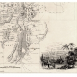
Map of the Holy Land depicting the land of Israel during the mid 19th century. The map shows the boundries of the 5 Roman Devisions Judea Samaria, Perea, the Decapolis, and Galilea. The map extends north to include all of Pheonicia and today's Lebanon and Syria. Biblical Jewish settlements, and Roman towns and villages as well as mountains rivers and wadies, are emphasized. The longitude is measured in two ways: East of Washington, and East of Greenwich. Until Greenwich England was selected in 1884 other cities were used to measure the longitude. This map is taken from Cram's Unrivaled Atlas of the World 1888 Chicago Ill. This atlas was first published in 1870. The map was drawn by George Cram himself. George F. Cram was born in 1841 and served with the Union forces in the Civil War Size of actual map: 28 X 41 cm (11 X 16 inches). Map is in overall good condition except for small tear in center fold.
Related Items
-
 Price: $65.00
 -
 Price: $55.00
 -
 Price: $150.00
Development: Epoch | Design: Luch
Copyright © 1999-2024 Gilai Collectibles. All Rights Reserved