
Old Maps and Globes > Jerusalem Maps
Plans of Jerusalem (4 sections) Printed by W R McPhun
Item#: MAJ255
SOLD
 Printed by W R McPhun - click to enlarge.")
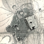
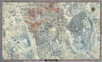
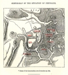
Plans of Jerusalem (4 sections) printed by W R McPhun. The four plans are : Ancient Jerusalem, showing the city at the time of the second temple. Modern Jerusalem showing Jerusalem in the 1850s. Plan of the Temple depicting an architectual plan of the inside of the second temple. Land of Moriah or the Enviorns of Jerusalem showing the area of the city from Bethel in the north to Bethlehem in the south. William Rae McPhun started his Glasgow business at 155 Trongate st. in 1825 he died in 1877. The map was printed and colored by WH McFarlane Lithographer. Size 22 X 32 cm (8.5 X12.5 inches)
Related Items
-
 Price: Contact us
 -
 Price: $250.00
 -
 Price: $76.00
Development: Epoch | Design: Luch
Copyright © 1999-2024 Gilai Collectibles. All Rights Reserved