
Old Maps and Globes > Jerusalem Maps
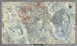
Hausermann Map of Jerusalem 1877. Published in Paris by Fayard Freres.
Item#: MAJ1110
SOLD


Plan De Jerusalem By Fayard. 1877. The map was drawn and engraved by R. Hausermann and published in Paris by Fayard Freres in their “Atlas Universel”. Year Printed: 1877. Size (W X H): 23.5 X 31.5 cm (9 ½ X 12 ½ inch). Original color printing with French legend. Scale: 70 meter to a cm. Map Description: The map extends from the valley of Jehosaphat in the north through Saint Cenacle Church in the south. The city is divided into 4 parts: Moriah (the Temple Mount), Musulmans, Juifs and Chretiens Quartiers. )The population of Jerusalem during the 1880’s totals approximately 18,000 Jews, 10,000 Arabs and 3000 Christians). Index and Explanations: Name list of 12 places of public importance are marked.
Related Items
-
 Price: $250.00
 -
 Price: $50.00
 -
 Price: Contact us
Development: Epoch | Design: Luch
Copyright © 1999-2024 Gilai Collectibles. All Rights Reserved