
Old Maps and Globes > Jerusalem Maps
Phillips & Hunt Map of Jerusalem 1886.
Item#: MAJ1109
SOLD


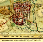
Map of Modern Jerusalem By Phillips & Hunt 1886. A color map, which was published in The People’s Atlas. Depicted are, the Walled city showing the 4 quarters and the Temple Mound including the Church of the Holy Sepulcher and the Wailing Wall. Outside the city walls, we can see the Russian Compound to the northwest, the Cenacle to the south and the Montefiore Cottages to the southwest. The map includes a reference table on the bottom left, the numbers coinciding with numbers on the map proper. On the back is a description of the Countries of Palestine (Judea Samaria etc.) Map size is 19X27 cm (7.5X10.5 inches). It is in very good condition, only very slight yellowing do to age.
Related Items
-
 Price: $350.00
 -
 Price: $65.00
 -
 Price: $50.00
Development: Epoch | Design: Luch
Copyright © 1999-2024 Gilai Collectibles. All Rights Reserved