
Old Maps and Globes > Jerusalem Maps
Wilkinson map of Jerusalem 1808. Land of Moriah or Jerusalem and the Adjacent Country.
Item#: MAJ1105
SOLD


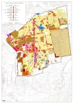
The Land of Moriah or Jerusalem and the Adjacent Country. This is the early Wilkinson map of Jerusalem engraved and printed on April 11th 1798. Robert Wilkinson that worked from 58 Cornhill Street in London published the map in his ‘Atlas Classica’ in the year 1808. This atlas contains a section with collection of maps of countries mentioned by ancient authors, both sacred and profane under the name ‘Geographia sacra’. Size: 27 cm (10 ¾ inch) X 33.5 cm (13 ¼ inch). Copperplate engraving printed on heavy paper with original hand coloring. The map depicts a plan of Jerusalem and the surrounding area including Bethlehem, Gibeon, Mount Calvary, Gethsemane, and The Temple on Mount Moriah. A similar map from a later edition (1825) could be found in the ‘Laor Collection’. This map was copied and published by Anthony Finley in 1831 as can be seen in the ‘David Rumsey Collection’.
Related Items
-
 Price: $65.00
 -
 Price: $76.00
 -
 Price: $60.00
Development: Epoch | Design: Luch
Copyright © 1999-2024 Gilai Collectibles. All Rights Reserved