
Old Maps and Globes > Jerusalem Maps
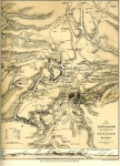
Map of the Environs of Jerusalem 1881. Made by H.H. Hardesty, Published by Jaeger & Co. U.S.A.
Item#: MAJ1104
SOLD


Map of the Environs of Jerusalem. This antique American map was made by H.H. Hardesty, Publisher and Proprietor, Chicago, Illinois and Toledo Ohio in 1879, based on an earlier map from 1850’s. The map was published in the "Historical Hand-Atlas" produced in 1881 by Godfrey Jaeger & Co. Size (width X height): 14 inch X 10 inch. Method: Lithography with original hand coloring. This important map covers the environs of Jerusalem from Ophrah and Bethel in the north to Tekoa and Gedor in the south. From Zorah and Zanoah in the west to Jericho in the east. The map shows the main mule trails (roads?) from Jerusalem to Hebron, Gaza, Jaffa and Jericho. Also shown are brooks, fountains, tombs, valleys and villages of historical importance.
Related Items
-
 Price: $60.00
 -
 Price: $350.00
 -
 Price: $76.00
Development: Epoch | Design: Luch
Copyright © 1999-2024 Gilai Collectibles. All Rights Reserved