
Old Maps and Globes > Jerusalem Maps
Map of Jerusalem 1881. Made by Hardesty, Published by Godfrey Jaeger & Co. U.S.A.
Item#: MAJ1103
SOLD


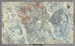
'1881. Original Map of Jerusalem. This antique American map was made by H.H. Hardesty, Publisher and Proprietor, Chicago, Illinois and Toledo Ohio in 1879, based on an earlier map from 1850’s. The map was published in the "Historical Hand-Atlas" produced in 1881 by Godfrey Jaeger & Co. Size (width X height): 10 inch X 14 inch. Method: Lithography with original hand coloring. This map of Jerusalem shows details of how the city within the walls was divided into 5 parts: Moriah (the Temple Mount), Mohammedan, Jewish, Christian and Armenian Quarters. (The population of Jerusalem during the 1850’s totals approximately 7,000 Jews, 5000 Arabs and 3000 Christians). The map was drawn prior to the initial building projects outside the city walls (The Jewish cottages - Montefiory, started in 1855 and the Russian Establishment near Jaffa Gate that started in 1860). This helped to date the map to the early 1850’s.
Related Items
-
 Price: $76.00
 -
 Price: $250.00
 -
 Price: $60.00
Development: Epoch | Design: Luch
Copyright © 1999-2024 Gilai Collectibles. All Rights Reserved