
Old Maps and Globes > Jerusalem Maps
Maps of Modern and Ancient Jerusalem 1883. Published by W.H. De Puy.
Item#: MAJ1102
SOLD


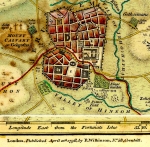
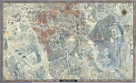
Original 1883 Maps of Modern and Ancient Jerusalem. Published by W.H. De Puy. Map source: Removed from “The People's Cyclopedia of Universal Knowledge, 1883.” Size (width X height): 12 inch X 9 ½ inch (the two maps together). Method: Lithography, printed in color. The detailed map of the modern city shows the two most important building projects in Jerusalem during to the 1860’s: the Russian Establishment near Jaffa Gate (started 1860, inaugurated 1872), and the Jewish cottages (Montefiory) (started 1855 inaugurated 1860). The missing ‘New Gate’ (opened in 1887) helped to date the map to early 1880’s. The city within the walls is divided into 5 parts: Moriah (the Temple Mount), Mohammedan, Jewish, Christian and Armenian Quarters. (The population of Jerusalem during the 1880’s totals approximately 18,000 Jews, 10,000 Arabs and 3000 Christians). The topographical contours and the ancient city boundaries are according to Charles W. Wilson, ‘Ordnance Survey of Jerusalem in the years 1864 – 1865’. Southampton 1866.
Related Items
-
 Price: $65.00
 -
 Price: $350.00
 -
 Price: $250.00
Development: Epoch | Design: Luch
Copyright © 1999-2024 Gilai Collectibles. All Rights Reserved