
Old Maps and Globes > Jerusalem Maps
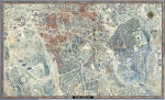
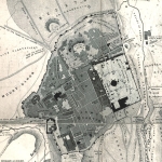
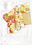
A set of 6 Historical Maps of Jerusalem 1907. Engraved by Bartholomew, Published by Hodder & Stoughton, London.
Item#: MAJ1099
SOLD


A set of 6 Historical Maps of Jerusalem. Engraved by the Scottish cartographer John George Bartholomew, the Edinburgh Geographical Institute. Published by Hodder & Stoughton, London. Year Printed: 1907. Size (width X Height): 15 X 17 inch. Printed in discrete 4 colors. Map Description: The maps summarize the research made by George Adam Smith and published in his book: Jerusalem, the Topography, Economics and History. Vol. I, and Vol. II, 1907. The template of each map is reduced by permission from the Palestine Exploration Fund’s plan of Jerusalem by Sir Charles W. Wilson, and the historical findings are printed in colors on top. The following maps are included: 1. The three northern walls. 2. Jerusalem under David. 3. Jerusalem under Solomon. 4. Jerusalem of the later monarchy and after the exile. 5. Jerusalem in the time of the Maccabees. 6. Jerusalem of the Herodian period.
Related Items
-
 Price: $250.00
 -
 Price: Contact us
 -
 Price: $65.00
Development: Epoch | Design: Luch
Copyright © 1999-2024 Gilai Collectibles. All Rights Reserved