
Old Maps and Globes > Jerusalem Maps
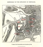
Map of Jerusalem 1859. Engraved by Bartholomew, Published by Blackie & Son London.
Item#: MAJ1091
SOLD

'The map was drawn and engraved by J. Bartholomew. Published by Blackie & Son London, Glasgow, Edinburgh, & Dublin. Year Printed: 1859. Size (W X H): 9 inch X 11 inch. Steel engraving, original color printing. Scale: 950 feet to an inch. Map Description: The map extends from the valley of Jehosaphat in the north through the Hill of the Evil Counsel in the south. The Russian Establishment near Jaffa Gate and the Jewish cottages (Montefiory) were in the process of being build. The first, second and third walls surrounding the city are delineated. The city is divided into 5 parts: Moriah (the Temple Mount), Mohammedan, Jewish, Christian and Armenian Quarters. (The population of Jerusalem during the 1850’s totals approximately 7,000 Jews, 5000 Arabs and 3000 Christians). Index and Explanations: Name list of 32 places of public importance are marked. Map Reference: This map is based on T. Tobler, ‘Planographic von Jerusalem (Memoir to the Plan of the Town and Environs…., by CWM Van de Velde), Gotha 1857.
Related Items
-
 Price: $76.00
 -
 Price: $65.00
 -
 Price: Contact us
Development: Epoch | Design: Luch
Copyright © 1999-2024 Gilai Collectibles. All Rights Reserved