
Old Maps and Globes > Holy Land Maps
Map of Canaan or the Land Of Promise 1854. Made by G. F. Cruchley, London.
Item#: MAH1085
SOLD

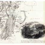
This is a very scarce map of Canaan Or The Land Of Promise, by G. F. Cruchley bearing the imprint date December 1st 1842. Addition to the publication date 1854. This is a large map 15 x 18 1/2 inches removed from Cruchley’s General Atlas. It is finely engraved and beautifully hand-colored, printed on heavy paper with elaborate cartouches at the top and bottom. The map shows the ancient boundaries and territories of the 12 Jewish tribes. These regions are individually hand-colored on the east and west side of the River Jordan. George Frederick Crutchley (1823-76) engraver, publisher, map-seller, and globe-maker worked at 81 Fleet Street, London.
Related Items
-
 Price: $65.00
 -
 Price: $30.00
 -
 Price: Contact us
Development: Epoch | Design: Luch
Copyright © 1999-2024 Gilai Collectibles. All Rights Reserved