
Old Maps and Globes > Holy Land Maps
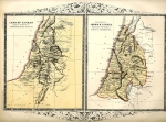
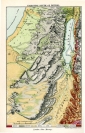
Map of the Trible Area of Dan 1812. (South Eastern Israel)

 - click to enlarge.")
Map of Holy Land, Tribe of Dan. The tribal area of Dan is from the Valley of Gaash in the north, to the valley of Sorek in the south. From the sea in the west, to Beth Shemesh and Nov in the east. The map depicts elevation, trees, camps, and vineyards are designated, along with symbols, which are explained in the legend at the bottom right corner of the map. . There is a drawing of a snake bitting a horse' hoof on the bottom right corner of the map(Genesis 49 17 " Dan shall be a serpent in the way,. a horned snake in the path, that bites the. horse’s heels, so that his rider falls backward".with the text "Tribe of Dan" above it. Map has latitudinal and longitudinal designations around the edges. Done in black ink, with English text black print on white, heavy stock paper. page from the book The Scripture Atlas printed for Mathews & Leigh in 1812
Related Items
-
 Price: $60.00
 -
 Price: $44.00
 -
 Price: $65.00
Development: Epoch | Design: Luch
Copyright © 1999-2024 Gilai Collectibles. All Rights Reserved